Hobart City Centre Neighbourhood Guide
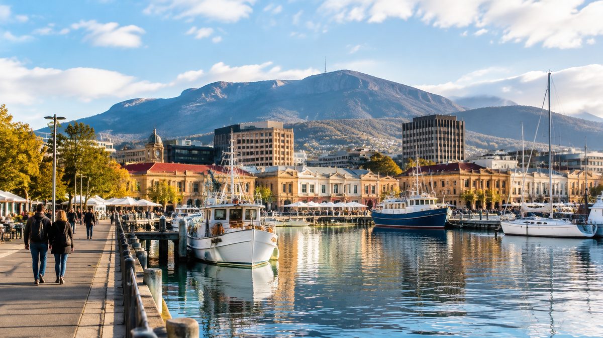
Hobart city centre is a compact, walkable district where the working city meets the waterfront and some of Tasmania's oldest streets. Its core is the central business district, but the neighbourhood makes more sense when viewed as several connected precincts. The retail grid, civic quarter, Sullivans Cove and Salamanca each have a different pace. Battery Point begins just beyond the centre yet feels closely tied to it.
This guide explains how those areas fit together. It focuses on orientation, street character and practical route choices rather than listing every cafe or attraction. The aim is to help you read the city as you walk through it.
Where does Hobart city centre begin and end?
There is no single official visitor boundary. For a useful walking definition, treat the city centre as the area between Brisbane Street in the north and Salamanca Place in the south. The River Derwent forms the eastern edge. The main commercial grid extends west towards Barrack Street, though the busiest blocks sit closer to Elizabeth Street and Murray Street.
This boundary includes the central business district, the civic buildings around Franklin Square and the waterfront around Sullivans Cove. It also reaches Parliament House, Hobart, Salamanca and the lower edge of Battery Point.
North Hobart is a separate neighbourhood. Its main dining strip begins farther up Elizabeth Street, beyond the compact office and retail core. The North Hobart Football Club and North Hobart Oval sit well outside the city-centre walking area described here. That distinction matters when booking accommodation or judging travel time from an event.
The centre is small on a map, but hills affect distance. A walk west from the waterfront climbs steadily. A route south into Battery Point can include steep lanes and steps. Street distance alone may understate the effort required.
How is the neighbourhood divided into useful precincts?
The retail grid occupies the blocks around Liverpool Street, Collins Street, Murray Street and Elizabeth Street. This is the practical city centre. It contains shops, offices and everyday services. Bus activity and weekday foot traffic are strongest here.
The civic quarter sits around Franklin Square, Macquarie Street and Davey Street. Government buildings, memorials and churches give these blocks a formal character. St Davids Cathedral, commonly written as St David's Cathedral, stands near the centre of this area. Its stone exterior and tower provide an easy point of reference when moving between the shopping streets and Salamanca.
The waterfront begins where the street grid meets Sullivans Cove. Here, working harbour space sits beside public paths, visitor facilities and converted historic buildings. Constitution Dock and Franklin Wharf are central to this precinct. Salamanca Place forms the southern waterfront edge, with Battery Point rising behind it.
These precincts are close enough to combine on foot. Their uses still differ. Someone who stays near Liverpool Street will experience a working city outside the door. A stay near Salamanca will feel more leisure-focused, especially during the evening and on weekends.
What gives the centre its character?
Hobart's city centre gains much of its identity from the close contact between old buildings, steep ground and an active port. Large towers have not erased the older street pattern. Narrow frontages and lanes remain visible between newer developments.
Georgian architecture is strongest around the waterfront and nearby historic areas. These buildings tend to use simple forms, even rows of windows and restrained detail. The sandstone warehouses at Salamanca are the most familiar large-scale example, although many have changed use since their industrial period.
Victorian architecture appears across later parts of the commercial grid. Decorative facades, arched windows and detailed parapets often survive above altered shopfronts. Looking up from street level reveals more of this fabric than scanning the ground-floor businesses.
The centre should not be treated as a preserved historic set. Deliveries, offices, traffic and port work remain part of the place. That mix explains why one block can feel administrative while the next opens towards fishing boats or a public lawn.
Which landmarks make the city easiest to understand?
Four landmarks provide a clear mental map. Franklin Square marks the civic centre. Constitution Dock identifies the inner harbour. Salamanca Place defines the southern waterfront. The Tasmanian Museum and Art Gallery sits near the point where the commercial grid meets Sullivans Cove.
Franklin Square is a useful pause between the upper city and the water. Macquarie Street runs along one side, while the blocks towards the harbour fall away from it. From here, the waterfront is close, even when buildings hide the river.
Constitution Dock is the most recognisable enclosed section of the harbour. Its small scale lets visitors see the link between the city and maritime activity at close range. It is also associated with the finish of the annual Sydney to Hobart Yacht Race, when the waterfront becomes much busier than usual.
Tasmanian Museum and Art Gallery occupies a group of historic buildings beside the harbour. Its position matters as much as its collections for orientation. It sits between the office grid and the open waterfront, making it a natural turning point on a city walk.
Farther south, Parliament House, Hobart faces the Salamanca area beside its lawns. It helps mark the change from the civic city to the warehouse precinct. Security needs and parliamentary business can affect access, so visitors should treat it as a working institution rather than assume every part is open.
What is the best route for seeing the centre on foot?
A loop beginning at Franklin Square gives the clearest introduction. Walk east towards the harbour and the Tasmanian Museum and Art Gallery. Continue around Constitution Dock, then follow the water along Franklin Wharf. Turn south towards Salamanca Place before returning through the civic quarter.
This route keeps the early section downhill and makes the city's layout easy to read. It also avoids repeated climbs between the commercial grid and the water. Allow about two hours for an unhurried walk, with more time if entering a museum, market or historic site.
To add Battery Point, continue from Salamanca towards Kelly's Steps or use a gentler street route. The steps create a direct link, but they are unsuitable for some wheelchairs, prams and people with limited mobility. The street alternative takes longer and still includes a climb.
A visitor with less time can walk from Franklin Square to Constitution Dock and return through the retail grid. That shorter route still shows the main contrast between Hobart's formal civic blocks and its harbour edge.
When does the city centre feel busiest?
Weekday mornings bring office workers, deliveries and school traffic into the central streets. The waterfront tends to build activity later, especially in mild weather. Some commercial blocks become quiet after office hours, while Salamanca and parts of the harbour remain active into the evening.
Saturday changes the pattern because Salamanca Market draws large crowds to Salamanca Place. The market operates during the day, subject to official schedules and any event changes. Parking becomes harder nearby, footpaths fill early and travel times increase around the southern edge of the centre.
Large events can reshape the waterfront. Yacht-race arrivals, festivals and public gatherings may close roads or limit access around Franklin Wharf and Constitution Dock. Checking official event notices before driving into the area can save a slow search for parking.
Sunday is usually quieter in the office grid. Some shops reduce their hours, so a quiet street does not mean the whole centre is inactive. The harbour, parks and Salamanca may still attract steady foot traffic.
Is the centre easy to explore without a car?
Yes. Walking is the most useful way to understand the neighbourhood because the main precincts sit close together. A car often adds parking limits, one-way streets and time spent circling busy blocks.
Metro buses use stops throughout the city, with major activity around the central streets. Routes and stop locations can change, so current information should come from the operator rather than an old visitor map. Taxis and booked rides are also easy to use, though waterfront events may shift pickup points.
Accessibility varies by street. The lower waterfront has broad, mostly level paths. The commercial grid includes sloping footpaths, road crossings and older surfaces. Some heritage buildings have access limits created by steps or narrow entries. A practical accessible route should favour the waterfront and check individual venues before arrival.
Cyclists can reach the centre from several directions, but busy intersections require care. Shared waterfront paths may also carry heavy pedestrian traffic. Walking a bicycle through crowded sections is often the safer choice.
Where should you stay for the kind of visit you want?
Choose the retail grid for direct access to city services, central bus stops and weekday business appointments. This area suits travellers who value function and short routes across the CBD. Street noise may rise early as deliveries begin.
Choose Sullivans Cove for harbour views and easy access to waterfront institutions. Accommodation here can place Constitution Dock and the museum within a short walk. Event noise and higher demand can affect some dates.
Choose the Salamanca edge for evening dining and access to the Saturday market. This area also provides the easiest transition into Battery Point. Market mornings can be crowded, and rooms close to late-night venues may carry more sound.
Battery Point suits visitors who prefer residential streets and historic character while remaining near the centre. It is outside the strict commercial core, and the climb back from the waterfront should form part of the booking decision.
What details do rushed visitors often miss?
The first missed detail is the upper level of commercial buildings. Modern signs often cover altered ground floors, while original windows and stonework survive above them. A slow walk along Murray Street or Elizabeth Street shows how Victorian architecture remains embedded in the working city.
The second is the shape of the original shoreline. Reclaimed ground changed parts of Sullivans Cove, so the present road edge does not always match the historic waterline. Museum displays and heritage markers can help explain why some early buildings now appear farther from the water than expected.
Another overlooked feature is the connection between public institutions and the port. Parliament, the museum, civic squares and working harbour facilities occupy a very small area. This closeness gives central Hobart its unusual scale.
Visitors also risk treating Salamanca Market as the whole Salamanca experience. The market occupies one day of the week. On other days, the warehouses, courtyards and links into Battery Point remain worth examining without the same crowd pressure.
How can you plan a useful first visit?
Start with the waterfront because it gives the clearest view of Hobart's shape. Then move inland through the civic blocks and finish in the commercial grid. This order makes the slope, harbour and street pattern easier to understand.
- Mark four points: Franklin Square, Constitution Dock, Salamanca Place and your accommodation.
- Check the day: Saturday market activity and major waterfront events can change walking conditions.
- Choose one extension: add Battery Point for historic streets or move farther into the CBD for shopping and services.
- Keep weather gear close: conditions can shift quickly near the river, even when the walk is short.
For more independent planning across the city, use The Hobart Field Guide as a starting point and confirm changing hours with each venue.
Actionable takeaway: Walk from Franklin Square to Constitution Dock, continue along Franklin Wharf to Salamanca Place, then return through the civic quarter for the clearest first view of Hobart city centre.