Hobart Historic Waterfront Guide
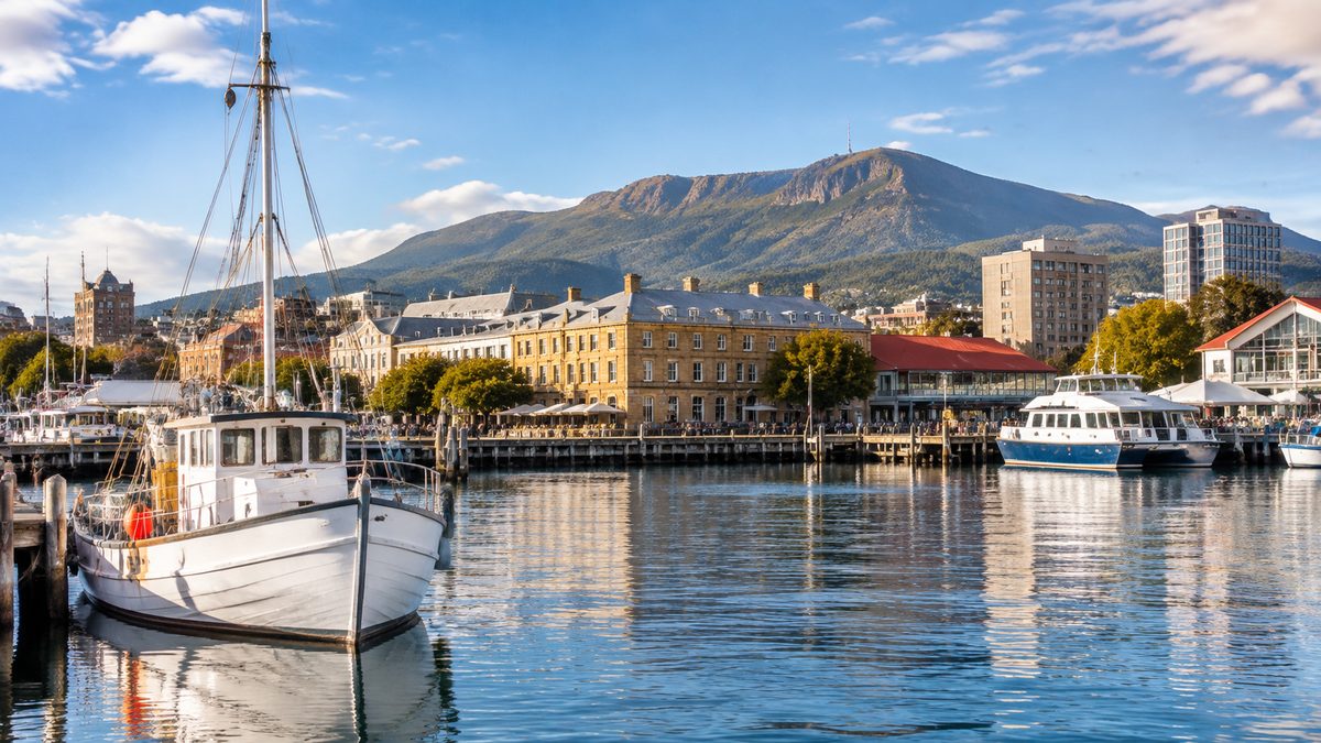
Hobart’s historic waterfront is best understood as a working colonial harbour that became part port, part civic centre and part public gathering place. Its sandstone buildings, dock basins and street lines reveal how shipping shaped the city. The useful question is not simply what looks old. It is what each place did, who used it and how the shore changed around it.
This guide from The Hobart Field Guide, an independent publication, explains how to read that history on the ground. It focuses on the meaning of the precinct rather than giving a turn-by-turn walking route or a list of places to eat.
Why did Hobart grow around Sullivans Cove?
Sullivans Cove became the centre of colonial Hobart because it offered sheltered water beside land suited to settlement. British colonists established the town on the western shore of the River Derwent in 1804. Ships supplied the settlement, carried people and connected Van Diemen’s Land with wider trade networks.
The present shoreline is not the same line seen by the first colonists. Reclamation pushed parts of the waterfront into the cove. Piers, causeways and dock works turned shallow edges into usable land. This explains why some old buildings now appear farther from the water than their original purpose would suggest.
The cove also depended on coercion. Convict labour supported colonial construction and public works, while Aboriginal Tasmanians suffered violent dispossession as British settlement expanded. A historic waterfront guide loses its meaning if it treats the precinct only as a set of attractive sandstone facades.
Look across the whole cove before studying single buildings. The enclosed water, nearby streets and remaining warehouses form one connected system. The harbour brought goods ashore, storage buildings held them, and roads moved them into town.
What do the old docks reveal about daily port life?
Constitution Dock is one of the clearest places to see how Hobart’s maritime history remains active. The enclosed basin dates from the 19th century and still holds working and recreational vessels. Fishing boats, yacht berths and dock structures keep it from feeling like a sealed museum display.
The dock is widely linked with the Sydney to Hobart Yacht Race. The race begins in Sydney Harbour and finishes on the River Derwent, with many yachts later gathering around Constitution Dock. Yacht racing brings a burst of public activity after Christmas, but the race is one chapter in a much longer port story.
Fishing also shaped the waterfront’s routines and identity. Boats unloaded catches near buyers, processors and markets. A modern seafood restaurant may draw on that harbour image, yet the older economy involved hard physical work, uncertain weather and changing catches. The polished dining edge and the working dock should be read as related spaces, not as the same experience.
A Cruise ship adds another layer. Large passenger vessels use Hobart as a visitor port, bringing intense foot traffic for a short period. Their scale makes the contrast with small historic dock basins easy to see. They also continue the waterfront’s old role as an arrival point, although today’s passengers enter a city built for tourism as well as trade.
Why does Salamanca Place look so different from a modern port?
Salamanca Place is defined by long rows of 19th-century sandstone warehouses. Merchants built these stores close to the harbour so cargo could move between ship, wharf and warehouse with less handling. Goods once tied to the colonial economy passed through this area, including wool, grain and imported supplies.
The buildings show how commercial function produced a strong visual style. Thick masonry walls offered durable storage. Repeated openings helped workers move goods between floors. Their form now feels formal, but it came from practical needs.
Many visitors describe the buildings as examples of Georgian architecture. That label is useful when it points to plain proportions, ordered facades and restrained detail. It becomes less useful when it turns every sandstone building into one vague style. Dates, later additions and original functions still matter.
The ground in front of the warehouses changed through reclamation. Salamanca Place was once much closer to the working shoreline. Lawns and public space now soften the setting, so it takes some effort to picture carts, cargo and harbour labour where people gather today.
Adaptive reuse saved much of the building stock by giving old warehouses new purposes. Galleries, shops and hospitality venues occupy spaces made for goods. That change keeps the structures in use, though interiors may reveal less of their industrial past than the outer walls.
How are Salamanca and Battery Point historically connected?
Battery Point rises directly behind the waterfront. Its slopes held homes for people from different levels of colonial society, including merchants, skilled workers and seafarers. The suburb therefore adds the human side of the port economy. Warehouses explain where goods went. The streets above help explain where some of the people tied to that trade lived.
The Battery Point Historic Precinct contains cottages, larger houses and street patterns from several periods. Building size and position can suggest differences in wealth, but appearances need care. A small cottage does not tell a complete story about every resident, and later restoration can make past living conditions look more comfortable than they were.
Kelly's Steps provide a direct physical link between Salamanca Place and the higher streets of Battery Point. The sandstone stairway was built in the 19th century and is associated with whaler and harbour figure James Kelly. Its value lies in what it shows about movement. The steep rise between port and neighbourhood was part of daily life, not a scenic detour.
From the upper streets, the relationship becomes easier to read. The waterfront supplied jobs and trade. The hillside provided homes and routes into the town. Modern property boundaries separate these areas more sharply than the old working patterns did.
What story does Hunter Street tell?
Hobart’s Hunter Street stands on land reshaped for port use and is closely tied to Hunter Island, which once sat apart from the original shore. Early works connected the island to the town, and later reclamation absorbed it into the waterfront. The street now marks one of the clearest examples of Hobart building outward into the cove.
The sandstone warehouses along this edge served shipping and storage. Their position near the water made commercial sense before road freight became dominant. Today, converted buildings and paved public areas can hide the former shoreline, so the street’s shape deserves as much attention as its facades.
Do not confuse this location with Hunter Street, Sydney. The shared name can produce misleading search results and map references. Hobart’s Hunter Street belongs to the history of Hunter Island and Sullivans Cove.
The causeway story also explains the cove’s unusual form. What looks like solid city ground may be filled land built over earlier water or tidal edges. This is one of the most useful ideas to carry across the whole waterfront.
Which civic buildings explain who controlled the waterfront?
Parliament House, Hobart sits beside Salamanca Place in a building that began as a customs house. Its location made sense because customs officers needed close access to vessels and imported goods. Customs duties, inspections and records made the harbour a place of government control as well as commerce.
The building later became the home of Tasmania’s Parliament. That change connects port administration with the growth of colonial government. Its calm classical form can make authority seem natural and fixed. The site’s changing use shows that institutions adapted existing waterfront assets as the town grew.
The Tasmanian Museum and Art Gallery occupies another key part of the historic harbour area. Its collections and buildings help place maritime objects within broader Tasmanian history. The museum is also useful for understanding that colonial Hobart did not begin on empty land. Aboriginal Tasmanian culture and survival extend far beyond the period represented by the colonial docks.
Nearby monuments and plaques vary in date and quality. Read their wording closely. Older interpretation may celebrate exploration or commerce while giving little space to convict labour, Aboriginal experience or environmental change. A plaque is evidence of how one period chose to remember another, not the final word.
Where does Antarctic history fit into the harbour story?
Hobart has long served as a southern port for Antarctic travel, science and supply. This role grows from geography, maritime skill and the city’s deep harbour. Antarctic vessels still make the waterfront feel connected to waters far beyond the Derwent.
Mawson's Huts Replica Museum near the waterfront interprets Douglas Mawson’s Australasian Antarctic Expedition of 1911 to 1914. The replica is not one of the original Mawson's Huts in Antarctica. That difference matters. It is an interpretive reconstruction designed to explain expedition life and support awareness of the surviving Antarctic structures.
The Antarctic link adds to the precinct without replacing its local history. Whaling, fishing, cargo work and colonial administration all left different marks. The harbour’s strength as a historic place comes from these overlapping uses and the physical evidence that remains.
How can you tell original fabric from later change?
Start with materials and joins. Older sandstone often shows weathering, tool marks and softened edges. A sudden change in stone colour or mortar can mark a repair. Bricked-up openings may reveal how a warehouse changed after its first use.
Then compare the building with the ground around it. A warehouse door that now opens well above a path may once have served a loading platform. A broad lawn may cover reclaimed land. Street levels can rise over time, leaving older thresholds lower than nearby paving.
Rooflines also provide clues. New plant equipment, modern dormers or altered parapets can show adaptation. These changes are not always damage. Continued use often funds maintenance, while strict preservation without a viable purpose can leave a building empty.
Public space carries recent history too. Market activity, festivals and race celebrations have changed how people know the waterfront. The goal is not to find a frozen colonial scene. It is to separate surviving evidence from later additions and understand why both are present.
What do quick visits usually miss?
Quick visits often reduce the waterfront to Salamanca’s sandstone row and boats in Constitution Dock. That view misses the changed shoreline beneath the paving. It also separates Battery Point from the port economy that helped shape it.
Another common mistake is treating every old building as a warehouse. Customs offices, stores, homes and later cultural buildings served different roles. Check names and dates before assigning a purpose based on appearance.
The hardest history is easiest to overlook. Convict labour helped build colonial infrastructure. Aboriginal Tasmanians experienced invasion and dispossession. Maritime industries could be dangerous and unstable. These facts do not cancel the waterfront’s beauty. They explain what the beauty alone cannot.
Season also changes what can be seen. Race crowds may hide small details around the docks, while quiet periods make building lines easier to study. Major events show the harbour in active public use, so neither condition gives a complete view by itself.
How should you read the waterfront as one historic place?
Use function as your guide. Ask what needed water access, what required storage and where authority was placed. Then look uphill to see how homes and streets connected with that work.
A useful order is to begin with the shape of Sullivans Cove, examine the dock basins and then study the warehouse fronts. From there, connect Salamanca Place with Battery Point through Kelly's Steps. Treat this as an interpretation method rather than a fixed walking route.
Keep the original shoreline in mind. Much of the present edge reflects human engineering. Once that fact is clear, isolated landmarks form a single story about a town that expanded across its harbour margin.
Actionable takeaway: when you visit, choose one old map or reliable heritage source and compare it with the present shoreline before judging any building in isolation.