Hobart Rivulet Walking Track
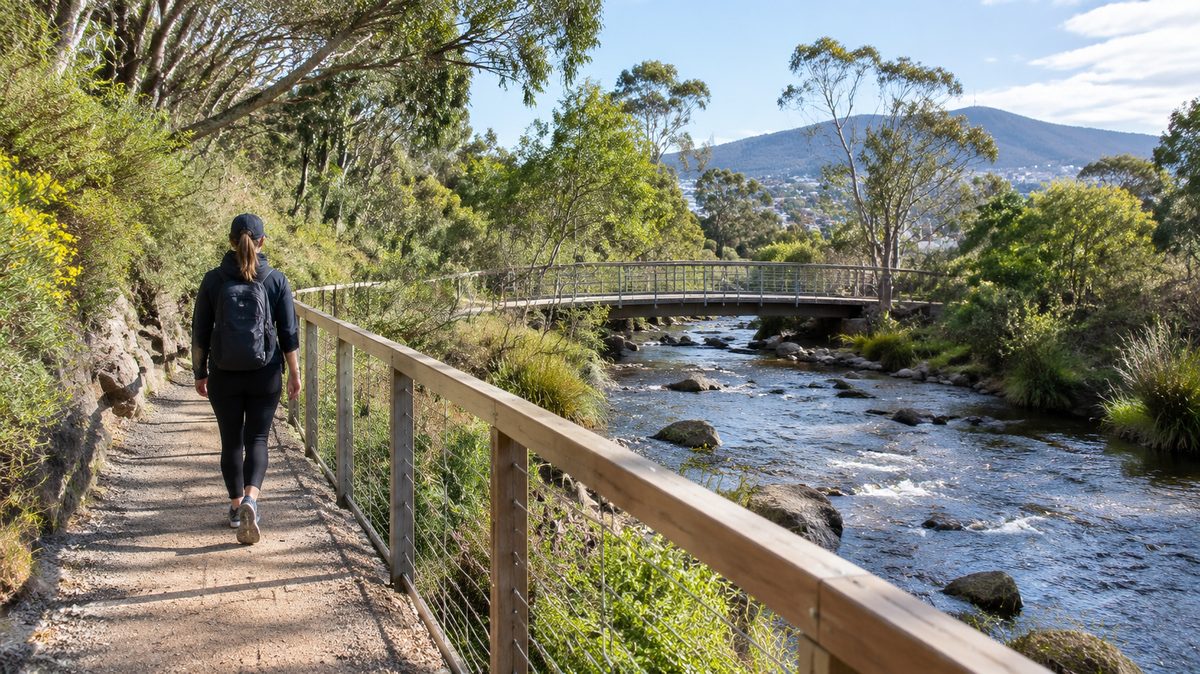
The Hobart Rivulet Walking Track is an easy urban walk linking the edge of Hobart City Centre with South Hobart and the Cascade Brewery area. The route follows the Hobart Rivulet through a narrow green corridor where sealed paths, quiet streets and sections of Bushland sit close to established homes. It works well as a short return walk, a one-way trip or a calm route between the city and the Foothills of kunanyi / Mount Wellington.
The main walking section is commonly treated as a route from near Molle Street to Cascade Gardens. It is about 2.7 kilometres each way, although the final distance changes with your starting point and any side trips. Most people should allow about an hour for a relaxed one-way walk. Add time for road crossings, interpretive signs, wildlife watching and a stop near the brewery.
Where does the track begin and end?
The most useful city-side access is near the western edge of Hobart City Centre, where the rivulet emerges from its underground course near Molle Street. From there, the path heads west through the Hobart Rivulet Linear Park towards South Hobart. The main track finishes around Cascade Gardens and the historic Cascade Brewery precinct.
The city end can feel less obvious than the mountain end because the waterway passes beneath central Hobart. Do not expect a grand trailhead in the middle of the city. The practical approach is to reach the Molle Street area, find the signed linear park and follow the rivulet upstream.
At the western end, Cascade Gardens provides a clear turning point. Cascade Brewery stands nearby, but access to brewery facilities, tours and hospitality is separate from access to the public walking track. Check current opening details before planning a visit around them.
Which direction gives the best walk?
Walking upstream from the city towards Cascade gives the route a clear sense of progression. Buildings thin out, the green corridor becomes stronger and the slopes below Wellington become more visible. The gradual rise is manageable for most regular walkers.
Starting at Cascade and walking towards the city offers an easier overall gradient. This direction suits people who want to finish near central shops, buses and food. It also makes a one-way trip simple if someone in the group prefers to avoid walking back uphill.
A return walk is the easiest option for visitors who do not want to study bus routes. Allow roughly two hours at a comfortable pace, plus any stops. The scenery changes enough in the opposite direction to keep the return leg interesting.
What is the walking surface like?
The route mixes firm shared paths with local street crossings and less formal sections. Much of it is easy underfoot, but it is not a perfectly level promenade. Tree roots, leaf litter, damp patches and small changes in grade can affect footing. Conditions become more slippery after rain.
Some parts can suit sturdy prams and many people using mobility aids, while barriers, cambers or connecting streets may make a full end-to-end trip harder. Anyone who needs step-free access should check the current City of Hobart path information before leaving. Construction, maintenance and flood damage can change access faster than general visitor guides are updated.
Cyclists also use parts of the corridor. Keep left, avoid blocking narrow points and listen for bells. Dogs need close control because the path passes homes, roads and areas used by wildlife. Follow the signs at each entrance, since leash requirements and permitted areas can change.
How do you stay on the right route?
Keep the rivulet as your main reference. The path sometimes moves away from the water or meets a road, but it returns to the same green corridor. Look for signs pointing along Hobart Rivulet Linear Park or towards Cascade Gardens.
At road crossings, pause and confirm where the path continues before moving on. The route is urban, so a wrong turn usually leads into a nearby residential street rather than remote ground. A phone map helps, but following the water upstream is often the clearest guide.
Do not enter drainage structures, culverts or fenced service areas. The rivulet disappears beneath roads and built land in places. Those gaps are part of the water system, not extensions of the walking route.
What will you see beside the rivulet?
The appeal comes from the contrast between the city and the creek corridor. One moment the path passes houses and retaining walls. A few minutes later, tree cover softens traffic noise and the water runs between rocks, roots and shaded banks.
The Riparian zone is the strip of land directly beside the water. Plants in this zone slow runoff, hold soil together and create shade. Fallen leaves and woody debris also support insects and other small life within the stream system. These features can look untidy beside a formal park, yet they perform useful work.
The corridor provides Habitat for birds, reptiles, aquatic animals and small mammals. Sightings are never guaranteed. Walk quietly near thicker vegetation, keep dogs away from the water's edge and leave fallen timber in place. Feeding wildlife can change its behaviour and attract pests.
Interpretive signs along the route explain parts of the area's natural and human history. Read them where they appear rather than relying on a single story about the creek. The rivulet has served as a natural watercourse, an industrial resource, an urban drain and a public green link.
Why did the rivulet matter to Hobart's growth?
Fresh Water supply influenced where early colonial Hobart developed. The rivulet carried water from the slopes below kunanyi / Mount Wellington towards the Derwent. Settlers drew from it while also placing homes, workshops and industry close to its banks.
That mix caused serious problems. Industrial waste, household pollution and changes to the channel reduced water quality. As the town expanded, parts of the lower rivulet were redirected and covered. The water still flows beneath central streets even when it is hidden from view.
The route also passes places linked with early industry. Milling, brewing and other work relied on flowing water or access to the valley. Cascade Brewery, established in the nineteenth century, remains the best-known landmark connected with this industrial corridor.
The track makes this history easy to read in physical form. Stonework, altered channels and buried sections show how the city tried to control the stream. Vegetated banks and public paths show the newer effort to treat it as a living corridor as well as drainage infrastructure.
How does the rivulet handle heavy rain?
The channel plays a direct role in Flood management. Rain falling across the slopes and developed areas enters the catchment, then moves towards the city through tributaries, drains and the rivulet itself. Water can rise quickly during intense rain.
A low flow on a clear day can create a false sense of safety. Fast water carries branches, stones and other debris. Low points beside the channel may flood before nearby streets appear dangerous. Never enter floodwater or cross a closed section of track.
Check the weather before setting out when heavy rain is forecast. Turn back if water covers the path, if authorities have installed barriers or if bank erosion has made an edge unstable. This is an urban walk, so there is no reason to push through a dangerous section.
Flood controls can protect property, but hard channels also change the creek's natural movement. Revegetated banks help slow surface runoff and reduce erosion in some areas. The track therefore offers a useful view of how urban safety, ecology and public access meet in one narrow space.
When is the best time to walk?
Morning gives the best chance of quieter paths and active birdlife. Late afternoon can be pleasant in warmer months, though shaded sections cool quickly. Winter brings damp ground and shorter daylight, while summer can leave exposed connections hotter than the tree-covered sections suggest.
Choose a dry day if you want the easiest footing. After light rain, the creek may look stronger and the vegetation can feel fresh, but wet leaves and mud demand more care. Avoid the corridor during severe weather or after warnings about local flooding.
Hobart weather can change quickly near the Foothills. Carry a light rain layer even when the city looks clear. Use sun protection on open sections and take drinking water, since a creek running beside the path does not make that water safe to drink.
What should you bring?
Normal walking clothes and enclosed shoes are enough in dry conditions. Shoes with grip are useful after rain. A small water bottle, sun protection and a light jacket cover the main needs without turning a city walk into an expedition.
Download a map or save the route before leaving if you are unfamiliar with South Hobart. Mobile reception is generally expected in this urban area, but a saved map makes road crossings and access points easier to identify.
Carry out all rubbish. There may be bins near parks and streets, but they are not a reason to leave food wrappers beside the water. Even small scraps can harm wildlife or wash downstream.
Can the walk connect with a longer day out?
The track fits neatly between a morning in Hobart City Centre and time in South Hobart. Walk upstream, pause at Cascade Gardens and return by the same route or use local transport. This keeps the day centred on the rivulet rather than turning the walk into a broad city tour.
Strong walkers can use South Hobart as a starting point for exploring routes closer to Wellington, but the Hobart Rivulet Walking Track is not a direct mountain summit trail. Bush tracks beyond the urban corridor require separate planning, suitable footwear and a fresh weather check.
Food and drink stops are available in the surrounding suburb and brewery area, subject to opening hours. Public toilets and other facilities should be checked before departure because access can change. The The Hobart Field Guide homepage can help place this walk alongside other local ideas without changing the simple upstream route.
What mistakes can spoil the walk?
The first is assuming that a creekside urban path stays flat, dry and fully separated from traffic. Expect crossings and changing surfaces. Watch children closely where the route meets roads or runs near steep banks.
The second is treating the water as safe for play or drinking. Urban waterways receive runoff from streets, properties and drains. Water quality can change after rain, even when the stream looks clear.
The third is planning around Cascade Brewery without checking its current hours or entry conditions. The public path and gardens can still form the walk's destination, but commercial venues operate on their own schedules.
The fourth is ignoring weather because the route sits inside the city. The catchment reaches into higher, wetter ground. Rain near Wellington can affect the rivulet even when conditions around central Hobart seem mild.
How should you plan the walk?
- Choose a return walk or arrange transport for a one-way trip.
- Check the Hobart forecast and avoid periods of heavy rain.
- Start near Molle Street or Cascade Gardens and follow signed public paths.
- Wear enclosed shoes, carry water and allow extra time for crossings.
- Stay out of the channel, respect closures and keep wildlife undisturbed.
Start near Molle Street, follow the rivulet upstream to Cascade Gardens, and turn back whenever weather, access or your available time says you should.