Kunanyi Mount Wellington Visitor Planning
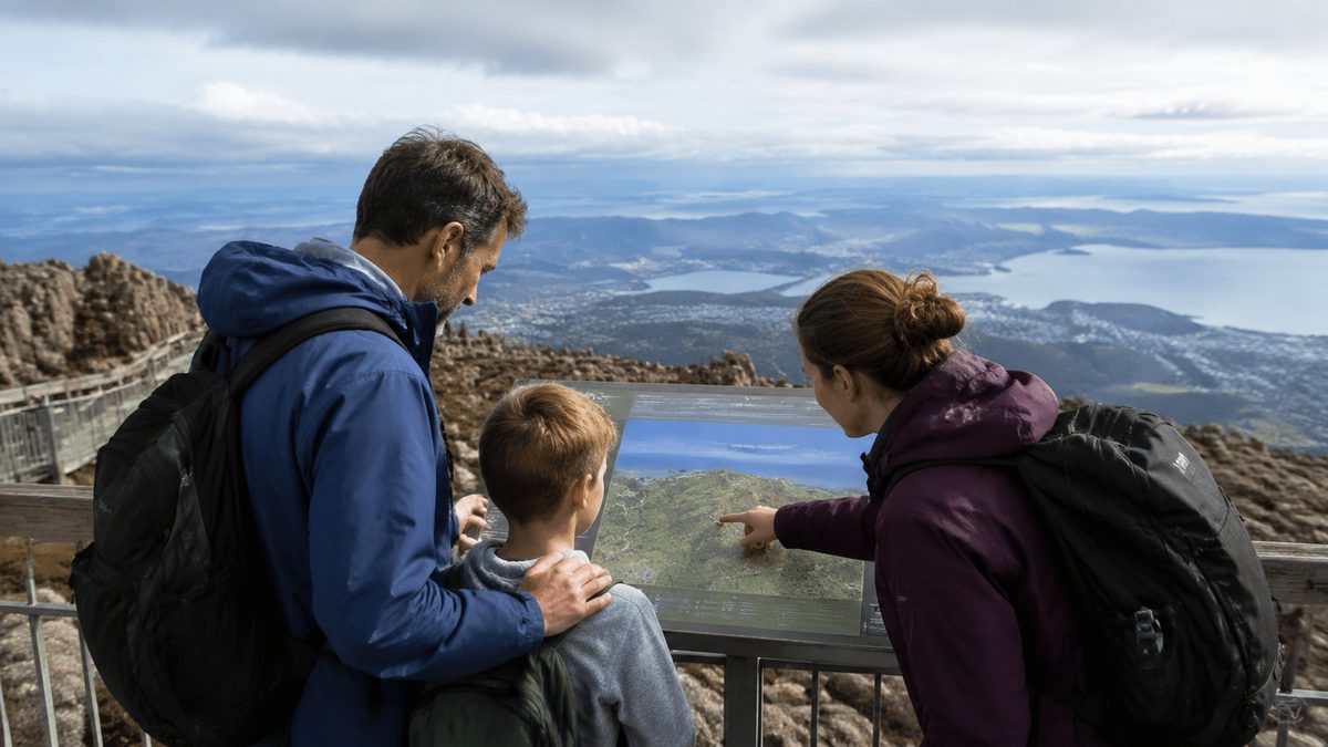
Plan your kunanyi / Mount Wellington visit around the mountain’s weather and access conditions, then choose transport, clothing and activities that still work if conditions change. The summit rises about 1,270 metres above sea level, yet it sits close to central Hobart. That quick rise means the temperature, wind and visibility can feel far removed from conditions beside the River Derwent. A clear morning in the city does not promise a clear summit.
The best plan has a preferred activity and a lower-altitude backup. Check official conditions before leaving, carry warm layers and avoid treating the summit as the only worthwhile stop. Wellington Park includes forest walks, picnic areas, cycling routes and lookouts across several height zones. You can still have a rewarding visit when cloud or a road closure rules out the top.
When should you check the mountain conditions?
Check the Weather forecast while planning, then check it again shortly before departure. Focus on the mountain forecast rather than Hobart alone. Summit temperature, wind speed, cloud level and possible rain matter more than the city’s headline temperature.
Conditions can shift during a visit. Pack for the coldest part of your route even if you expect to spend only a few minutes outside at the summit. A warm layer and a rainproof outer layer belong in your bag throughout the year. Wear closed shoes with useful grip. Add gloves and a beanie when cold conditions are forecast.
Cloud affects more than the view. It can hide track markers, make road edges harder to read and leave exposed surfaces wet. Strong wind can also make a mild temperature feel much colder. Turn back or move to a sheltered, lower site if walking becomes uncomfortable or visibility falls.
Snow and ice sometimes affect access. Do not assume a hire car, small car or bicycle will be suitable because traffic is still moving below the mountain. Check official Wellington Park notices and road information before setting out.
How should you choose between driving and public transport?
Driving gives you the most control over timing and lets you move between lower stops and the summit when Pinnacle Road is open. It also creates pressure at popular times because parking is limited at several sites. Leave room in your schedule to change stops rather than waiting in a crowded area or parking outside marked spaces.
Pinnacle Road is steep, narrow and exposed in places. Drive to the conditions, stay alert for cyclists and follow every closure sign. A road closure applies even when the weather appears safe from below. Gates and restrictions protect visitors from hazards that may be hidden higher up.
Public transport can work well for a lower-mountain day. Metro Tasmania services can help visitors reach the Fern Tree area, but timetables and routes can change. Check the current service before travel and confirm the location of the return stop. Regular urban services should not be assumed to continue to the summit.
Visitors without a car can also compare current commercial transport options from central Hobart. Confirm whether a ticket includes a summit stop, how long passengers receive at each stop and what happens during a road closure. A service that shifts to lower lookouts in poor conditions may provide more value than one built around a single summit visit.
What should you plan to do at the summit?
Keep the summit plan simple. Allow time to look across the city and surrounding ranges, read the site information and use the Pinnacle Observation Shelter when conditions are harsh. The shelter offers protection, but it does not remove the need for suitable clothing. You still need to cross exposed ground between a vehicle, viewing areas and the shelter.
On a clear day, the changing view rewards a slow circuit more than a rushed photo stop. Look for Hobart and the River Derwent below, then turn towards the broad mountain country beyond the city. Cloud may reveal one direction while hiding another, so wait a few minutes before deciding there is nothing to see.
Stay behind barriers and keep away from exposed edges. Rock can be slick after rain or frost. The wind may also be stronger near openings and lookout points than it is beside parked vehicles.
Do not build a fixed day around a guaranteed summit view. If the summit is hidden, spend more time on a sheltered forest walk or at a lower lookout. This approach prevents a normal mountain weather change from spoiling the whole visit.
Which lower-mountain stops are worth including?
Fern Tree, Tasmania is a practical base for short walks and a useful alternative when the summit is cold, crowded or closed. The forest offers a different view of the mountain. Tall trees, shaded paths and running water can make the lower slopes feel separate from the bare, exposed summit.
Choose a walk by distance, climb and track conditions rather than by its name or a single online photo. Read the sign at the track entrance. Check whether the route returns to the same point and note any junctions. A short track with steep or wet sections may take longer than its distance suggests.
Groups should set a clear turnaround time before leaving the trailhead. The slowest walker should shape the pace. If one person lacks warm clothing, food or suitable footwear, select a shorter route near a settled area.
Waterfalls and shaded tracks may carry more water after rain, but wet timber and stone become slippery. Stay on formed paths. Shortcuts damage plants, widen muddy ground and can place walkers above steep drops.
How much time should you allow?
Allow at least half a day if you want both the summit and a lower-mountain stop. A summit-only trip can be shorter, but traffic, road conditions and shifting cloud may alter the timing. A full day gives walkers more choice, provided the selected route matches their skill and daylight.
Early visits often provide easier parking, though no time guarantees clear skies. Late visits may bring attractive light, yet they require closer attention to sunset and falling temperature. Finish walks before darkness unless you have planned a night activity and carry the right equipment.
Place the mountain visit on a flexible part of a Hobart stay. If two days are possible, use the clearer forecast window for the summit. Move indoor city activities to the poorer day. This small change can improve the visit without adding cost.
What do walkers need before leaving the track entrance?
Take a map or saved route that remains available without mobile reception. Tell someone where you are going and when you expect to return. Carry water, food, warm clothing and a charged phone. Longer or remote routes require equipment suited to their terrain and forecast conditions.
Do not use online time estimates as a deadline. Walking speed changes with fitness, mud, steep climbs and photo stops. Start with enough daylight to return at a calm pace. If the route begins taking much longer than planned, turn around early.
Track names can appear similar, and paths may connect with wider networks. Confirm each junction instead of following the people ahead. They may be travelling to another destination.
Keep children close near roads, steep ground and water. Dogs face restrictions within parts of Wellington Park, so check the rules before bringing one. Wildlife should be watched from a distance and never fed.
How should cyclists and drivers share the mountain?
A road cyclist or Mountain bike rider needs a route suited to the activity. Some trails permit bikes while others do not. Check the current park map and obey signs at each trailhead. A path that looks rideable is not proof that riding is allowed.
Riders should expect fast weather changes and cooler conditions during descents. Carry a windproof layer and basic repair gear. Use lights when visibility is poor, even during the day. Control speed around walkers and announce your approach without startling them.
Drivers should pass cyclists only when there is enough clear space. Blind bends and narrow sections demand patience. Cyclists should ride predictably and use marked pull-off areas when stopping. Nobody should stop in a traffic lane for a photo.
What should you do if access changes after you arrive?
Follow signs, gates and directions from staff. Do not drive around a barrier or enter a closed track. Closures may respond to ice, fire danger, fallen trees or active works. The cause may not be visible from your position.
Emergency management starts with avoiding a preventable rescue. Change the route when official advice changes. If someone is injured or lost, call Triple Zero for a serious emergency. Give the operator the track name, last known location and any nearby marker. Stay together unless moving is needed to escape an immediate danger.
Mobile reception can vary, so earlier preparation still matters. A charged phone cannot replace a route plan, suitable clothing or a realistic turnaround time. If your party becomes uncertain about its position, stop and check the map before walking farther.
How can you reduce your impact on the mountain?
Apply Leave No Trace principles throughout the visit. Carry rubbish out, remain on formed tracks and leave rocks or plants where they are. Use toilets where provided and plan ahead for places without facilities.
Keep noise low near wildlife and other visitors. Avoid trampling track edges while passing people. If a path is muddy, walk through the firm centre where safe instead of creating a new line through plants.
Smoke, cooking equipment and flames can create serious risk during dry periods. Follow current fire restrictions. Never assume cool summit air means the wider park has a low fire risk.
The mountain has deep cultural meaning for Tasmanian Aboriginal people. Use the name kunanyi with respect and follow requests attached to protected places. Treat signs and barriers as part of caring for the site rather than obstacles to a photograph.
What common planning mistakes spoil a visit?
The first mistake is dressing for the city. The second is making the summit view the sole goal. Another is starting a walk without checking its return distance and daylight needs. Each error comes from treating the mountain like an urban lookout instead of a high, changeable environment.
Overloading the day also reduces its value. Driving to every marked stop leaves little time to notice the change from wet forest to exposed alpine ground. Select one main activity and keep one backup nearby.
Visitors also lose time when they depend on live mobile data for every decision. Save the route, transport details and key park notices before departure. For broader city planning before or after the mountain, use The Hobart Field Guide, an independent local publication.
What should you do before setting out?
- Check the mountain Weather and current Wellington Park alerts.
- Confirm whether Pinnacle Road and your chosen track are open.
- Choose transport and verify Metro Tasmania times if travelling through Fern Tree.
- Pack warm and waterproof layers, water, food and a charged phone.
- Set a turnaround time and save a lower-altitude backup plan.
Make the final go-or-change decision from the latest mountain conditions, then follow the safer plan even if it means skipping the summit.